


 For years, Federal agencies have struggled to drive efficiencies while addressing the growing volume and increasing size of geospatial data. Legacy stove-pipe connectivity and desktop thick-clients have prevented traditional production environments from achieving the potential of a modern cloud-based architecture. Coupled with responsive web-based components, the cloud offers a seamless framework to automate tasks such as data ingestion, pre-processing and product generation. AIS is proud to be helping our users migrate into these next-generation production environments.
Our Federal team is currently involved with multiple projects that foster the adoption of cloud-based tasking, ingestion, processing and visualization using open-source web technologies. We foster an approach to migrating data processing algorithms from research groups across the Intelligence Community into production environments such as AWS Commercial Cloud Services (C2S).
For instance, the open-sourced NGA Scale framework allows users to customize heavy data processing schedules and tasks, while leveraging and managing a large number of cluster nodes used to process each job.
Right…. So what does that mean, exactly?
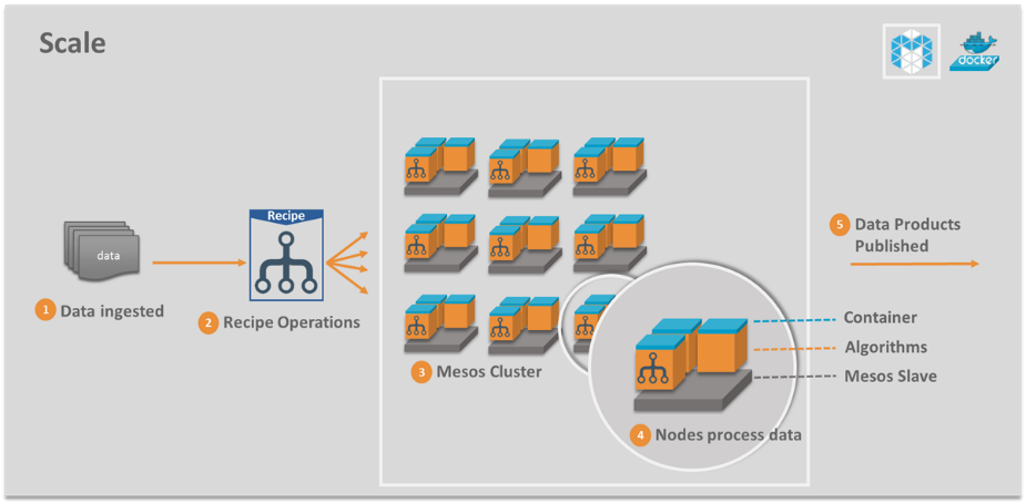
As a user, imagine arriving at your desk each morning and having your data readily available and processed for you to analyze. No more waiting for data to arrive, assessing the quality of each dataset, and spending time pre-processing each dataset using thick-clients. It’s just done. Now you can focus your time and energy on accomplishing the task of turning that data into useful information.
In order to do this, one could continue relying upon the dependencies of traditional desktop clients, or migrate to a modern web-based approach to visualizing data, which has the advantage of being de-centralized and often much faster. Tools like Sigma and Spectre (which our team showcased at SXSW) allow users to visualize and manipulate geospatial data via the browser, reducing the overall time spent during analysis.
Forces combined, a solution like Scale can revolutionize data processing workflows, while web-based tools drive major efficiencies to users. That’s the power of the cloud!
Soon, the adoption of the AWS Secret Region C2S, will become available to non-IC members of the U.S. Government who also hold Secret-level network access. AIS is poised to be a provider of custom service migration, deployment and sustainment in these C2S environments as our experience is growing and expanding across multiple offices and agencies throughout the Public Sector.
As for those parties without access to C2S, we bring an even more diverse cloud-based solution offering, with the same understanding of the geospatial data problem set and ability to improve and enhance the production concept of operations (CONOPS). Specifically for DoD agencies, our Cloud Adoption Framework describes our five-step process by which we can effectively transition an organization’s workflow into an environment such as AWS GovCloud or Azure Gov.
Are you ready to shape your own custom geospatial cloud adoption strategy? Contact my team to get started!
FREE HALF DAY SESSION: APP MODERNIZATION APPROACHES & BEST PRACTICES
Transform your business into a modern enterprise that engages customers, supports innovation, and has a competitive advantage, all while cutting costs with cloud-based app modernization.